Sapa Local Guides · Vietnam · August 2026
Ban Ho Village, Sapa — Tay Community, Stilt Houses & Lower Valley Homestays
Introduction to Ban Ho Village
Ban Ho is the lower-valley anchor of Sapa multi-day trekking — the riverside Tay commune where three-day routes typically spend their final homestay night after walking through upper Black Hmong terrace country, Giay riverside sections of Muong Hoa Valley, and Red Dao forest valleys. Where villages such as Lao Chai and Ta Van dominate one-day tourism, Ban Ho marks a geographic and cultural shift southward: greener walls, warmer air, stilt houses above the stream, and fish-based family meals that distinguish Tay hospitality from upper-slope trekking stops.
Ban Ho is not a day-trip suburb of Sapa Town. Most travellers reach it on foot after two days of valley walking — not by motorbike taxi on a crowded road loop. That access pattern preserves quieter atmosphere compared with Ta Phin or the Lao Chai–Ta Van corridor, though homestay hosting on guided routes still intersects daily agricultural life in working households.
Understanding Ban Ho as a named place within Sapa's multi-ethnic geography prevents treating it as an interchangeable "homestay night" on a product brochure. Tay families farm riverside fields, maintain footpaths shared with trekkers, and open wooden homes under arrangements negotiated through local guides — a living community beneath the southern foothills of the Hoang Lien Mountains, not a hotel zone with rice terrace wallpaper.
For trip-wide planning — seasons, homestays, route choice, and how Ban Ho fits beside Muong Hoa trekking — see The Complete Sapa Travel Guide, Homestay in Sapa — What to Expect, and Best Time to Visit Sapa.
Where Is Ban Ho Village?
Ban Ho lies south of the main Muong Hoa tourist loop in Ban Ho commune, Sa Pa district, Lao Cai Province — a lower river valley reachable on foot from downstream Muong Hoa routes through Giang Ta Chai, Su Pan, and neighbouring watersheds. Sapa Town sits on the basin rim to the north at roughly 1,500 metres; Ban Ho is lower, greener, and warmer in feel than upper villages such as Y Linh Ho or Lao Chai.
Geographically, Ban Ho occupies the southern edge of the Sapa trekking network — where steep Hoang Lien ridges descend toward broader river corridors and Tay stilt-house settlements cluster beside water. Clear weather from terrace paths above may frame distant ridgelines; mist and valley cloud hide panoramas as often as they reveal them.
Footpaths connect Ban Ho uphill toward Muong Hoa communes and downstream toward hamlets such as Nam Toong and Thanh Phu on the same three-day corridor. Road access exists in parts of the commune for local transport and supply runs, but guided trekking approaches typically arrive walking — preserving the sense of descent into lower mountain country that defines the 3-Day Sapa Valley & Village Trek.
Most visitors reach Ban Ho on day two or three of a multi-day itinerary — after upper-valley cultural transitions from Hmong terraces through Giay and Red Dao country. Independent day visits without guide arrangements are uncommon and not recommended for homestay logistics.
Why Ban Ho Is Different from Muong Hoa Villages
Muong Hoa Valley — Lao Chai, Ta Van, Giang Ta Chai — is the famous river corridor west and south of Sapa Town where most one-day and two-day treks concentrate. Ban Ho belongs to a **different watershed** further south: lower elevation, broader green valley walls, Tay rather than Hmong or Giay dominance, and tourism traffic filtered by multi-day commitment rather than morning bus drops.
**Elevation and climate:** Ban Ho feels warmer and more humid than upper Muong Hoa. Rice seasons and daily rhythm shift accordingly — planting and harvest timing may differ from terraces above Lao Chai on the same calendar week.
**Ethnic geography:** Upper Muong Hoa is predominantly Black Hmong and Giay with Red Dao downstream at Giang Ta Chai. Ban Ho is Tay country — stilt houses, fish agriculture, Tai-Kadai language and cuisine distinct from Hmong indigo culture or Dao embroidery traditions.
**Tourism character:** Lao Chai–Ta Van sees heavy foot traffic on standard day routes. Ban Ho sees trekkers who booked three-day products or custom expeditions — fewer crowds, less bracelet-selling pressure on paths, but also less infrastructure for independent travellers expecting restaurant strips or spa tourism.
**Landscape register:** Muong Hoa upper sections offer stacked terrace panoramas; Ban Ho offers enclosed green valley walls, stream sound, and riverside agriculture — photogenic in a softer register than the vertical drama above Y Linh Ho.
Compare explicitly with Ta Van Village — Giay middle Muong Hoa — and Giang Ta Chai Village — Red Dao forest downstream — to understand how one mountain system supports distinct village experiences by elevation and ethnicity.
Tay Community
Ban Ho is primarily a Tay village commune — the best-known Tay settlement anchor on Sapa multi-day trekking routes. Tay identity here expresses through stilt-house architecture, wet rice and fish agriculture, woven textiles less commercially visible than Hmong market spectacle, and hospitality customs emphasising shared meals and tea.
For full cultural context on language, history, festivals, and comparison with neighbouring groups, read the dedicated Tay people guide. Ban Ho is one village expression of that broader culture — the place where three-day trekkers typically **experience** Tay homestay life rather than read about it abstractly.
Multicultural contact still defines regional life. Black Hmong and Red Dao neighbours appear on trade paths and shared market days in Sapa Town. Giay communities upstream in Muong Hoa occupy middle river sections Ban Ho trekkers passed through earlier on the same route. Ban Ho is not ethnically isolated — it is the Tay anchor in a valley network where groups coexist while maintaining distinct languages and customs.
Neighbouring hamlets Nam Toong and Thanh Phu extend the same Tay cultural zone on the three-day corridor — smaller settlements with similar stilt-house life and agricultural rhythm.
Traditional Stilt Houses
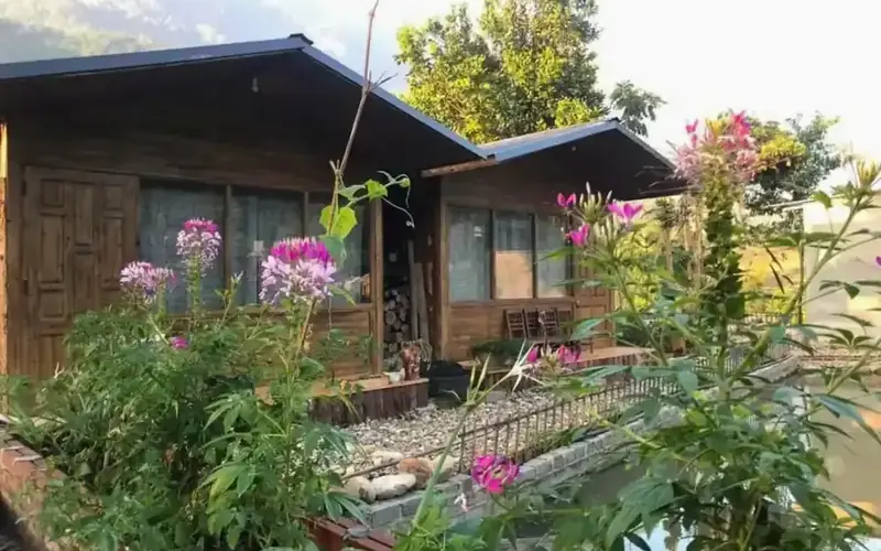
Tay homes in Ban Ho use stilt-house architecture — wooden structures raised above ground on posts, with living space on the upper level and storage, livestock pens, or workspace beneath. This form suits riverside humidity, seasonal flood risk on lower valley floors, ventilation in warmer temperatures, and protection from ground moisture during monsoon months.
Construction combines timber framing, bamboo wall panels, and metal or tile roofs on most modern buildings. Houses orient toward river views and afternoon sun where terrain allows. Stone or concrete footings stabilise posts on sloped sites. Bamboo from managed groves supplies fencing, flooring, and household use.
The main living level centres on a kitchen and gathering space — fire for cooking, heat in cooler evenings, and social heart of the household. Sleeping areas may be partitioned or on raised platforms. Homestay guests sleep in the same buildings — simple mattresses, blankets, mosquito nets — within working family space rather than purpose-built lodge wings.
Livestock — pigs, poultry, sometimes buffalo — occupy ground level or nearby sheds. Fish ponds or river weirs may sit adjacent to homes — protein sources integral to Tay valley economy.
Compare with Giay stilt houses in Ta Van — similar raised forms on middle Muong Hoa — and Black Hmong ground-level homes on upper terraces. Architecture signals ethnic adaptation and elevation within a single multi-day trek.
Rice Terraces and Valley Landscape
Ban Ho's landscape combines riverside greenery with rice terraces on surrounding slopes — broader and softer than the stacked walls above Y Linh Ho, but no less central to livelihood. Terraces curve along valley walls above the stream; alluvial fields sit nearer the river where water access is most reliable. They are not the Muong Hoa day-trek amphitheatre — see Sapa Rice Terraces.
Rice cultivation follows monsoon calendars shared across the Sapa region — planting floods, green growth, golden harvest — with timing that often lags or leads upper Muong Hoa phases by weeks due to lower elevation. Seasonal colour shifts reward attentive trekkers: mirror-bright water at planting, emerald summer green, autumn gold, quieter fallow periods in winter.
Valley walls enclose Ban Ho in green — forest margins on ridges above, stream corridors below, stilt houses scattered along slopes rather than clustering in a single grid. On clear days, paths above hamlets may frame the Hoang Lien skyline; mist rising from the river at dawn can hide terraces entirely.
Terraces are farmland, not backdrop. Staying on established paths, avoiding shortcutting through planted fields, and respecting irrigation channels protects household income directly — especially when guests walk the same paths farmers use daily.
For terrace photography timing, see Best Time to Visit Sapa. For range-wide geography, see the Hoang Lien Mountains guide.
Streams and Waterfalls
Water defines Ban Ho's physical character — the stream that names and sustains the valley runs through agricultural land, past stilt houses, and along footpaths trekkers follow on approach and departure. Stream volume varies seasonally — vigorous after mountain rain, quieter in dry months — affecting crossing safety and waterfall visibility on side paths.
Side valleys and tributary courses above Ban Ho hold smaller cascades and pool sections that local guides may visit on three-day routes depending on weather, fitness, and time. These are not theme-park waterfall stops — they are forest-and-stream features within working watershed country where paths may be slick after rain and swimming requires explicit local guidance.
Wet season (roughly May–August) swells streams quickly; waterproof footwear and cautious footing matter. Dry season reduces volume but increases dust on exposed paths — trade-offs familiar across lower Hoang Lien valleys.
Respect water sources as household infrastructure — do not pollute streams, avoid disruptive behaviour at washing or irrigation points, and follow your guide on safe crossing locations rather than improvising on unstable rocks.
Agriculture and Daily Life
Ban Ho's economy combines terrace rice cultivation, riverside vegetables, fish ponds and river weirs, livestock, and tourism-related income from homestays on multi-day routes. Daily rhythm follows agricultural cycles: early field work, animal and fish feeding, school paths active mid-morning, cooking and craft work in afternoons, early nights in quieter seasons.
Water buffalo remain important for ploughing where slopes permit. Pigs and poultry provide protein and market sales. Fish — pond-raised or river-weir managed — distinguishes Tay valley meals from upper Hmong homestay cooking trekkers experienced on night one.
Tourism intersects this schedule without replacing it. Homestay hosts prepare guest meals around their own family cooking; guides lead groups through while neighbours continue farming. Children walk to school on paths shared with trekkers — an overlap that demands reduced speed and noise near households.
Income distribution is uneven, as in Ta Van: families on main homestay routes benefit more visibly than households on quiet side ridges. Private tours with local guides who pay homestay hosts directly support more equitable benefit than mass tourism where intermediaries absorb payments.
Elders hold knowledge of irrigation repair, fish management, food preservation, and calendar festivals. Younger generations may migrate seasonally to towns, though homestay income creates reasons for some to remain.
Homestay Experience
Ban Ho homestays appear primarily on multi-day trekking routes — especially the second or third night of the 3-Day Sapa Valley & Village Trek after upper Muong Hoa and Giang Ta Chai sections. Tay hosting offers riverside stilt-house experience, fish-inclusive family meals, and quieter valley atmosphere than the busiest corridor above Ta Van.
Homestay accommodation places travellers in working households — simple mattresses, shared blankets, mosquito nets, and bathroom facilities that may be basic by urban standards but reflect genuine family hospitality. Read Homestay in Sapa — What to Expect before any overnight village stay.
**What to expect:** Meals arrive when ready; sleeping arrangements follow household capacity; hot water may be limited; evening social life centres on the kitchen and fire. Shoes come off at doorways; offered tea and food carry social weight — accept or decline graciously through your guide.
**What surprises guests:** Animal sounds beneath stilt floors; early roosters; simpler bedding than hotels; meals that emphasize rice, vegetables, and fish rather than restaurant variety. These are features of authentic hosting, not service failures.
Custom homestay combinations — extended Tay valley stays, quieter hamlets such as Nam Toong, or multi-village routes — can be discussed through Private Sapa Expeditions when standard products do not match your interests.
Sapa Local Guides requires a minimum of two paying travellers on private tours. Homestay payments arranged through operators with direct village relationships support hosting families more reliably than independent bookings through opaque intermediaries.
Trekking and Walking Routes
Ban Ho is reached on foot through established multi-day corridors — not typically as a standalone day trek from Sapa Town.
**Standard three-day approach:** Day one descends through upper Muong Hoa — Black Hmong terraces, Giay sections, cultural transitions documented in village guides for Lao Chai, Ta Van, and Giang Ta Chai. Day two continues through Red Dao forest country toward lower watersheds. Day three traverses or departs from Ban Ho and neighbouring Tay hamlets before returning toward Sapa.
**Fitness and pacing:** Reaching Ban Ho involves sustained walking over two prior days — moderate fitness suffices with guide support, but cumulative descent and ascent matter more than single-day gradient statistics suggest.
**Weather:** Lower valley paths may be warm and humid while upper ridges remain cool and misty on the same morning — layer clothing and trust guide daily assessment over town-level forecast apps.
**Beyond Ban Ho:** Routes may continue toward Nam Toong, Thanh Phu, or custom ridge connections on private expeditions — gateway country toward even quieter Tay watersheds south of the standard product corridor.
Compare route character with Which Sapa Trek Is Right for You if choosing between two-day Muong Hoa homestays and three-day valley cross-sections that include Ban Ho.
Connection with the 3-Day Sapa Mountain Trek
The 3-Day Sapa Valley & Village Trek is the primary Sapa Local Guides product that places guests in Ban Ho — the broadest ethnic cross-section among standard trekking offerings, with two homestay nights and a final day through Tay river valley country.
**Why Ban Ho anchors the route:** Three-day itineraries need geographic progression — upper Hmong terraces, middle Giay and Red Dao transitions, lower Tay hospitality — that one watershed alone cannot supply. Ban Ho provides the lower-valley climax: warmer climate, fish meals, stilt-house nights, and cultural contrast that rewards the walking investment of prior days.
**Typical rhythm (product logic, not fixed daily script):** Homestay nights may split between Giay or Red Dao country mid-route and Tay Ban Ho on the final valley night — exact sequencing depends on guide routing, season, and household availability.
**Who should choose it:** Travellers with three to four nights in Sapa who want maximum village diversity without remote expedition difficulty. Read How Many Days Do You Need in Sapa to align calendar days with product length — three-day treks need travel bookends beyond the product name.
**Who might skip it:** Travellers with only two nights who cannot extend; those satisfied with Lao Chai–Ta Van only; hikers seeking alpine ridge focus rather than ethnic valley cross-section.
Custom pacing and village combinations beyond the standard product — extended Ban Ho stays, alternate hamlets — are available through Private Sapa Expeditions.
Responsible Visiting
Ban Ho receives less day-trip traffic than Ta Van or Ta Phin — but multi-day trekking still brings photography pressure, litter, and expectations shaped by social media rather than village reality.
Practices that support Tay communities:
- •Book private multi-day tours with local guides employed directly
- •Ask permission before photographing people, homes, and meals
- •Stay on established paths; do not enter houses uninvited
- •Buy produce and crafts from makers at fair prices
- •Carry out all litter; do not give candy or money to children on paths
- •Respect homestay simplicity — read [Homestay in Sapa — What to Expect](/stories/homestay-in-sapa-what-to-expect) before overnight stays
- •Understand that Ban Ho rewards multi-day commitment — not drive-by tourism
Compare responsible norms with the Tay people guide for cultural context and with the Muong Hoa Valley guide for corridor-wide trekking etiquette on days before you reach Ban Ho.
Sapa Local Guides does not treat Ban Ho as a backdrop homestay checkbox; guides facilitate introductions, translate conversations, and manage logistics while families continue daily life around guests.
Frequently Asked Questions
What is Ban Ho known for?
Ban Ho is known as a Tay village commune in lower southern Sapa country — riverside stilt houses, green valley walls, fish-based homestay meals, and its role as the typical final homestay anchor on three-day valley trekking routes.
Is Ban Ho in Muong Hoa Valley?
Ban Ho is connected to the broader Sapa trekking network through footpaths from Muong Hoa downstream sections, but it sits in its own lower river valley south of the main Lao Chai–Ta Van tourist loop — geographically and culturally distinct from upper Muong Hoa.
Which ethnic group lives in Ban Ho?
Ban Ho is predominantly Tay. Upper Muong Hoa villages are primarily Black Hmong and Giay; Red Dao communities appear at Giang Ta Chai and Ta Phin on other routes.
How do I reach Ban Ho?
Most travellers reach Ban Ho on foot through multi-day guided trekking — primarily the 3-Day Sapa Valley & Village Trek. Independent homestay stays without guide arrangements are not recommended.
Can I visit Ban Ho on a one-day trek?
Unlikely. Standard one-day routes stay in upper and middle Muong Hoa. Ban Ho requires multi-day descent — typically day two or three of a three-day product.
What is the homestay like?
Simple family accommodation in stilt houses — mattresses, shared facilities, home-cooked meals including fish and rice. Read Homestay in Sapa — What to Expect and the Tay people guide for cultural context.
When is the best season to visit?
September through November offers golden rice and clearer skies; March through May provides green terraces with manageable rain. Lower Ban Ho is warmer than upper Muong Hoa. Month-by-month detail: Best Time to Visit Sapa.
How does Ban Ho relate to the Hoang Lien Mountains?
Ban Ho sits on the southern foothills of the Hoang Lien massif — lower river farmland with ridge forest above and summit zones far beyond daily village life. See the Hoang Lien Mountains guide for range context.
Does Sapa Local Guides operate in Ban Ho?
Yes — primarily through the 3-Day Sapa Valley & Village Trek and custom routes via Private Sapa Expeditions.
Ban Ho endures because Tay families continue farming, raising fish, and opening homes along a valley that tourism did not create — only joined. Walk through with that understanding, and the stream sound, stilt-house lights at dusk, and shared meal around the fire become part of a place worth knowing by name.
Compare bookable routes: Ban Ho tours.
Envie de créer votre propre histoire ?
Rejoignez un trek ou un homestay à Sapa et vivez la vraie montagne.
Demander sur WhatsApp